
by T. C. Folsom
Whatcom County is approximately 110 miles (34 m) from east to west with the northern border at the 49th parallel, i.e. the border between the USA and Canada. The county is only about 26 miles (7.6 m) from north to south. Point Roberts marks the western side of Boundary Bay at the 49th parallel and the eastern edge of the county is within the crystalline core of the North Cascades mountain chain.
At the eastern side of Boundary Bay is a broad plain characterized by alluvial soil and glacial till left by ice sheets. It is a productive farming area. South of Bellingham the land rises up to the Chuckanut Mountains which are characterized by sandstone with various occurrences of fossils. Moving east we encounter the foothills of the Cascades with a varied geology, including more of the Chuckanut sandstone, e.g. Slide Mountain. Farther east is the stratovolcano Mt. Baker and the complex geology of the North Cascades.
Lake Whatcom lies in a narrow valley east of Bellingham and is one of the largest lakes in northwestern Washington. Through its geologic history the lake has been a stream valley, a glacially scoured trough filled with ice, an arm of the sea and a freshwater lake (Easterbrook, 2010**). As Easterbrook (2010) notes, during at least six major Ice Ages over the last two million years, glaciers deepened and widened the valley floor creating a trough up to 328 feet (100 m) deep.
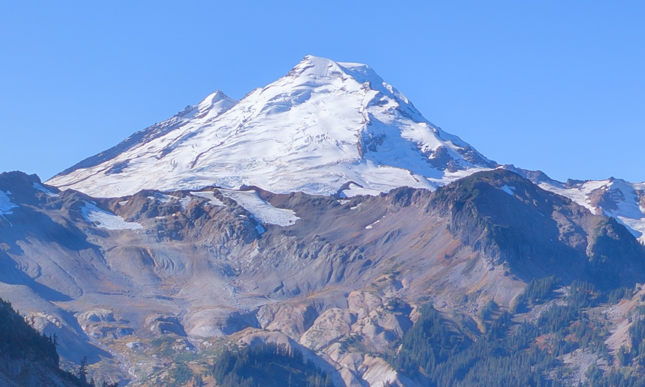
Mount Baker (10,778′, 3285 m) is one of a long chain of volcanoes on the Cascade crest from northern California to southern British Columbia. The three eruptive centers are the summit dome, Sherman Crater, and the Black buttes which are eroded remnants of an older cone (Easterbrook, 2010). The fascinating landscape around Mt. Baker is most easily visited at Heather Meadows and Artist Point. The Fire and Ice trail at Heather Meadows has interpretative signs along with exposures of 301,000 year old columnar lava flows.
The youngest lava flows at the summit cone are 9-20,000 years old, while the Sherman Crater is younger (Easterbrook, 2010) . Eruptions from the crater are mainly ash and pumice. Steam can periodically be seen venting from this crater!
The North Cascades mountain range is relatively young so glaciation, erosion, landslides, etc. have produced spectacular vistas of rugged ridges and peaks unlike the rounded mounds of older ranges. The oldest rocks in the Whatcom part of the range are the Yellow Aster crystalline rocks that formed in the Earth’s crust during the Precambrian Era (1.8 B years ago) (Easterbrook, 2010).
Another major area of the Cascades is defined by the Chilliwack Group. Some 400 M years ago, the north- central part of Whatcom county lay beneath the sea. The sea floor turned into sandstone, shale, chert and limestone (Easterbrook, 2010) . Volcanic rocks in this area metamorphosed into greenstones (actinolite and epidote).
One of the most recognizable peaks after Mt. Baker is Mt. Shuksan, best viewed from Heather Meadows. This peak is largely comprised of Shuksan greenschist, a metamorphosed basaltic lava of late Jurassic age (Easterbrook, 2010) . The metamorphism occurred in a subduction zone at a depth of 15-20 miles (Brown 2017). The green color comes from chlorite, epidote, and actinolite. The upper part of the mountain has been thrust faulted over Darrington phyllite.
The Darrington phyllite is a foliated metamorphic rock that was shale, siltstone, and sandstone. The phyllite is about 150 M years old, and it can be found in a large area south of the Chuckanut mountains and Lake Whatcom (Easterbrook, 2010) .
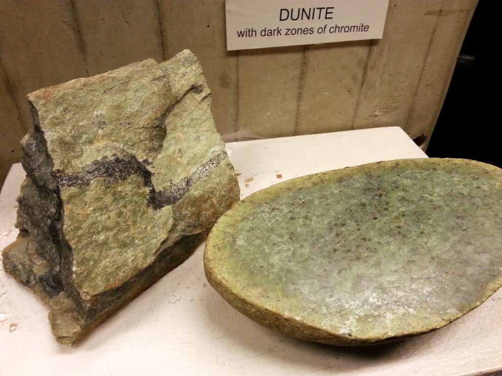
A unique area of Whatcom county is the Twin Sisters mountain range (see image above taken from Park Butte). It is comprised entirely of Dunite (below), a rock composed of Olivine with some Chromite. Per Easterbrook (2010), entire ranges of Dunite are quite rare. This mass of Dunite broke off from the mantle below the crust and was thrust up along a fault. Because Olivine lacks certain minerals that plants need, the slopes of the Twin Sisters are relatively bare compared to other areas at the same elevations.
Further east and to the eastern border of Whatcom County is the area called the Cascade Crystalline Core and known more popularly as “The American Alps”. The core is the south end of the 1000-mile long Coast Plutonic Complex (Brown 2017). The core is nothing if not extremely complicated with multiple plutons and terranes mashed together. The exposed rocks are mainly granite, schist, and diorite (Brown 2017) which make for rugged peaks and excellent mountaineering opportunities. Refer to Brown (2017) and Tabor (1999) for more details.
- Honeycomb weathering in Chuckanut Sandstone .
- Lone Jack gold mine
Brown, N. 2017, Mountain Building Geology in the Pacific Northwest. Chuckanut Editions, Bellingham, WA
Easterbrook, D.J. 2010, A Walk Through Geologic Time from Mt. Baker to Bellingham Bay, Chuckanut Editions, Bellingham, WA
Tabor, R.W., 1999, Geology of the North Cascades, A Mountain Mosaic. The Mountaineers, Seattle, WA.